Web Map Service (WMS)
Basemap service in WMS format. Contains regularly updated data layers on roads, populated places, land use, hydrography, railroads, buildings and several types of points of interest, shown either as pictograms (as churches, hills, rail stations, airports) or as labels (governmental and municipal institutions, schools, supermarkets etc.).
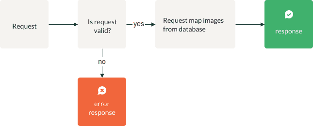
Process
| Name | Type | Explanation |
|---|---|---|
| Response message | Message End | The application creates response message according to "Response message" chapter |
| Request information from the database | Action | API queries the database with request parameters |
| Is the request valid? | Gateway | The application verifies request parameters |
| Error response | Message End | The application creates error response according to "Verification" chapter |
Request parameters
Request consists of the following URI parameters:
| Parameter | Possible values | Default value | Required | Description |
|---|---|---|---|---|
apikey |
string | - | Yes | Your authorization key |
request |
GetMap GetCapabilities |
- | Yes | GetMap request retrieves a map from a WMS site. GetMap allows the client to specify distinct layers, the spatial reference system, the geographic area, and other parameters describing the returned map format. Upon receiving the GetMap request, a WMS site will either satisfy the request or send an error message in accordance with the exception instructions contained in the GetMap request.GetCapabilities request provides information about a WMS service, such as image formats it can serve, list of one or more map layers available in the service etc. |
format |
image/png | image/png | Yes | Only png is supported at the moment. This parameter is optional and defaults to png. For GetMap request only. |
service |
WMS | - | No | For GetMap request only. |
layers |
GDHdefault GDHdefault_bw |
- | Yes | Defines visual output of the WMS.GDHdefault stands for colour version, GDHdefault_bw stands for grayscale version. |
version |
1.0.0 1.3.0 |
- | Yes | Defines the version of WMS service. For GetMap request only. |
srs |
EPSG:3857 EPSG:3301 EPSG:3059 |
- | Yes | Spatial reference system of the basemap. Supported values include EPSG:3857 (i.e., Web Mercator), EPSG:3059 (Latvian coordinate system), EPSG:3301 (Estonian coordinate system). For GetMap request only. |
crs |
EPSG:3857 EPSG:3301 EPSG:3059 |
- | No | Same as srs, but |
bbox |
floating point number, floating point number, floating point number, floating point number |
- | Yes | Defines bounding box with two coordinate pairs (minx,miny,maxx,maxy) in coordinate system matching srs/crs parameter value. For GetMap request only. There may be required different coordinate pair sequence based on which WMS version is used, refer to the appropriate WMS version specification, that can be found on the internet. |
width |
integer | - | Yes | Width in pixels of the resulting map image. For GetMap request only. |
height |
integer | - | Yes | Height in pixels of the resulting map image. For GetMap request only. |
transparent |
true, false | false | No | Map background transparency. For GetMap request only. |
GetMap request example
https://api.geodatahub.eu/wms/service?layers=[]&format=[image format]&srs=[spatial reference system code]&exceptions=[]&transparent=[]&service=[]&version=[]&request=[request type]&styles=[]&bbox=[bounding box coordinates]&width=[image width in pixels]&height=[image hight in pixels]&apikey=[API_KEY]
GetCapabilities request example (for desktop applications)
https://api.geodatahub.eu/wms/service?request=GetCapabilities&apikey=[APIkey]
Verification
| Verification | errorCode | errorName | errorDescription |
|---|---|---|---|
| Is layer defined correctly in the request? | 400 | Bad Request | "unknown layer" |
| Is API key in the request? | 401 | Unauthorized | "No API key found in request" |
| Is API key correct in request? | 403 | Forbidden | "Invalid authentication credentials" |
| Is API key active? | 403 | Forbidden | "Invalid authentication credentials" |
| Is format defined correctly in the request? | 400 | Bad Request | "unsupported image format" |
| Is request defined correctly in the request? | 400 | Bad Request | "unknown WMS request type" |
| Is service defined correctly in the request? | 500 | Internal Server Error | "Internal error" |
| Is weigth/height values defined correctly in the request? | 500 | Internal Server Error | "Internal error" |
| A parameter is missing. | 400 | Bad Request | "missing parameters" |
| Is EPSG code correct in the request (crs)? | 400 | Bad Request | "unsupported crs" |
| Is EPSG code correct in the request (srs)? | 400 | Bad Request | "unsupported srs" |
| Is bbox defined correctly in the request? | 400 | Bad Request | "invalid bbox" |
Scales by zoom levels
| Zoom level | Scale |
|---|---|
| 1 | 1:279 541 132.01428574 |
| 2 | 1:139 770 566.00714287 |
| 3 | 1:69 885 283.00357144 |
| 4 | 1:34 942 641.50178572 |
| 5 | 1:17 471 320.75089286 |
| 6 | 1:8 735 660.375464285 |
| 7 | 1:4 367 830.187714286 |
| 8 | 1:2 183 915.093860714 |
| 9 | 1:1 091 957.546932143 |
| 10 | 1:545 978.7734642858 |
| 11 | 1:272 989.38673285715 |
| 12 | 1:136 494.69336642858 |
| 13 | 1:68 247.34668321429 |
| 14 | 1:34 123.673341607144 |
| 15 | 1:17 061.836670785713 |
| 16 | 1:8 530.918335392857 |
| 17 | 1:4 265.459167714285 |
| 18 | 1:2 132.7295838500004 |
| 19 | 1:1 066.3647919250002 |
Response
- HTTP status = 200;
- Body consists of the following values:
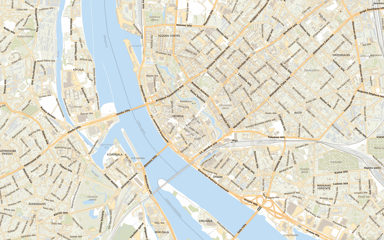
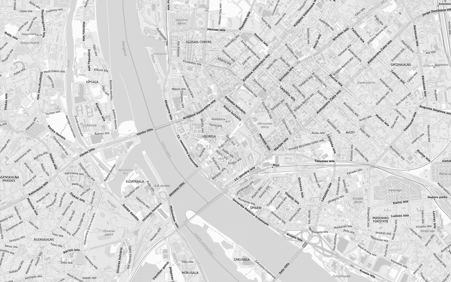
GetMap output examples
Output when layers=GDHdefault
Output when layers=GDHdefault_bw
GetCapabilities output example
<?xml version="1.0"?>
<!DOCTYPE WMT_MS_Capabilities SYSTEM "http://schemas.opengis.net/wms/1.1.1/WMS_MS_Capabilities.dtd"
[
<!ELEMENT VendorSpecificCapabilities EMPTY>
]>
<!-- end of DOCTYPE declaration -->
<WMT_MS_Capabilities version="1.1.1">
<Service>
<Name>OGC:WMS</Name>
<Title>GeoDataHub WMS services</Title>
<Abstract>GeoDataHub WMS services</Abstract>
<OnlineResource xmlns:xlink="http://www.w3.org/1999/xlink" xlink:href="http://bgm-api.reach-u.com/wms/service"/>
<Fees>none</Fees>
<AccessConstraints>none</AccessConstraints>
</Service>
<Capability>
<Request>
<GetCapabilities>
<Format>application/vnd.ogc.wms_xml</Format>
<DCPType>
<HTTP>
<Get>
<OnlineResource xmlns:xlink="http://www.w3.org/1999/xlink" xlink:href="http://bgm-api.reach-u.com/wms/service?"/>
</Get>
</HTTP>
</DCPType>
</GetCapabilities>
<GetMap>
<Format>image/png</Format>
<Format>image/jpeg</Format>
<Format>image/gif</Format>
<Format>image/GeoTIFF</Format>
<Format>image/tiff</Format>
<DCPType>
<HTTP>
<Get>
<OnlineResource xmlns:xlink="http://www.w3.org/1999/xlink" xlink:href="http://bgm-api.reach-u.com/wms/service?"/>
</Get>
</HTTP>
</DCPType>
</GetMap>
<GetFeatureInfo>
<Format>text/plain</Format>
<Format>text/html</Format>
<Format>application/vnd.ogc.gml</Format>
<DCPType>
<HTTP>
<Get>
<OnlineResource xmlns:xlink="http://www.w3.org/1999/xlink" xlink:href="http://bgm-api.reach-u.com/wms/service?"/>
</Get>
</HTTP>
</DCPType>
</GetFeatureInfo>
</Request>
<Exception>
<Format>application/vnd.ogc.se_xml</Format>
<Format>application/vnd.ogc.se_inimage</Format>
<Format>application/vnd.ogc.se_blank</Format>
</Exception>
<Layer>
<Title>GeoDataHub WMS services</Title>
<SRS>EPSG:3059</SRS>
<SRS>EPSG:3301</SRS>
<SRS>EPSG:3857</SRS>
<LatLonBoundingBox minx="19.072265625" miny="53.3833283676" maxx="32.0361328125" maxy="60.8020637447" />
<BoundingBox SRS="EPSG:3857" minx="2123114.89765" miny="7054220.46638" maxx="3566245.99167" maxy="8580515.04718" />
<ScaleHint max="4525.48339959" />
<Layer>
<Name>GDHdefault</Name>
<Title>GeoDataHub default basemap</Title>
<LatLonBoundingBox minx="19.072265625" miny="53.3833283676" maxx="32.0361328125" maxy="60.8020637447" />
<BoundingBox SRS="EPSG:3857" minx="2123114.89765" miny="7054220.46638" maxx="3566245.99167" maxy="8580515.04718" />
<ScaleHint max="4525.48339959" />
</Layer>
<Layer>
<Name>GDHdefault_ee</Name>
<Title>GeoDataHub default basemap in EPSG :3301 projection</Title>
<LatLonBoundingBox minx="19.072265625" miny="53.3833283676" maxx="32.0361328125" maxy="60.8020637447" />
<BoundingBox SRS="EPSG:3857" minx="2123114.89765" miny="7054220.46638" maxx="3566245.99167" maxy="8580515.04718" />
<ScaleHint max="4525.48339959" />
</Layer>
<Layer>
<Name>GDHdefault_bw</Name>
<Title>GeoDataHub default basemap in grayscale color</Title>
<LatLonBoundingBox minx="19.072265625" miny="53.3833283676" maxx="32.0361328125" maxy="60.8020637447" />
<BoundingBox SRS="EPSG:3857" minx="2123114.89765" miny="7054220.46638" maxx="3566245.99167" maxy="8580515.04718" />
<ScaleHint max="4525.48339959" />
</Layer>
<Layer>
<Name>GDHdefault_ee_tms_wmts</Name>
<Title>GeoDataHub default basemap for TMS/WMTS in EPSG:3301 projection</Title>
<LatLonBoundingBox minx="19.072265625" miny="53.3833283676" maxx="32.0361328125" maxy="60.8020637447" />
<BoundingBox SRS="EPSG:3857" minx="2123114.89765" miny="7054220.46638" maxx="3566245.99167" maxy="8580515.04718" />
<ScaleHint max="4525.48339959" />
</Layer>
<Layer>
<Name>GDHdefault_lv_tms_wmts</Name>
<Title>GeoDataHub default basemap for TMS/WMTS in EPSG:3059 projection</Title>
<LatLonBoundingBox minx="19.072265625" miny="53.3833283676" maxx="30.72395096" maxy="59.5316414106" />
<BoundingBox SRS="EPSG:3857" minx="2123114.89765" miny="7054220.46638" maxx="3420174.57602" maxy="8296193.16146" />
<ScaleHint max="4525.48339959" />
</Layer>
</Layer>
</Capability>
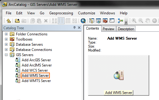
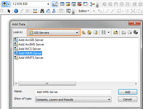
</WMT_MS_Capabilities>Step-by-step guide to insert WMS into ArcGIS
-
Create account and get your api key at www.geodatahub.eu
-
ArcCatalog: GIS Servers - Add WMS Server -
-
ArcMap: Add Data - GIS Servers - Add WMS Server -
-
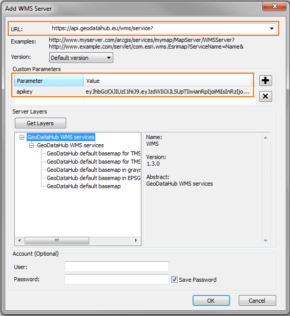
URL: https://api.geodatahub.eu/wms/service? Add Custom Parameter Parameter: apikey Value: insert your api key (token)
Data sources and updates
Area of Latvia and Lithuania is covered by Jāņa Sēta's data. Area of Estonia is covered by Maa-amet (Estonian Land Board) and © OpenStreetMap contributors data.
The content is updated quarterly.