Reverse geocoder
Reverse Geocode API is for finding readable address or place name for geographical coordinates (point location).
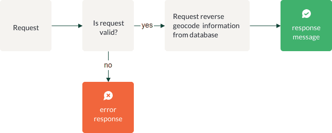
Process
| Name | Type | Explanation |
|---|---|---|
| Is request valid? | Gateway | Application verifies request parameters |
| Error response | Message End | Application creates error response according to "Verification" chapter |
| Request reverse geocode information from database | Action | API queries database with request parameters |
| Response message | Message End | Application creates response message according to "Response message" chapter |
Request parameters
Request consists of the following URI parameters:
| Parameter | Possible values | Default value | Required | Description |
|---|---|---|---|---|
lat |
double | Yes (A) | Latitude. E.g. 58.37 | |
lon |
double | Yes (A) | Longitude. E.g. 26.71 | |
x |
double | Yes (B) | X coordinate (for example in LKS-92 (EPSG:25884) coordinate system) | |
y |
double | Yes (B) | Y coordinate (for example in LKS-92 (EPSG:25884) coordinate system) | |
region |
est, lva, ltu | No | Dataset id by country such as est, lva, ltu etc. The codes are set according to ISO-3166-1 standard. Defines the area where data is searched from. This parameter may be specified multiple times, to merge results from multiple datasets. Example: ...®ion=est,ltu&... |
|
lang |
et, lv, lt | No | If lang is not defined, output is given in all available languages. If lang is defined, addresses are searched and output is given in these languages only. |
|
apikey |
string | Yes | Your authorisation key | |
rs |
string | TO BE SPECIFIED | ||
type |
xml, json | json | No | The format in which the output should be generated. |
crs |
string | 4326 | B | Spatial reference system of the query and response. Supported values include EPSG:4326 (i. e. WGS84 geographical coordinates) and EPSG:3301 (i. e. L-EST97, the Estonian national projected coordinate system), as well as the EPSG codes for the UTM projections. |
limit |
integer | 1 | No | Max value 25 |
Request URL example
https://api.geodatahub.eu/rgc?apikey=[API KEY]&y=[Y coordinate]&x=[X coordinate]&lang=[output language]&type=[response type]&crs=[EPSG code]&limit=[output limit]
Verification
| Verification | errorCode | errorName | errorDescription |
|---|---|---|---|
| Is API key in request? | 400 | Bad Request | No API key found in request |
| Is API key correct in request? | 401 | Unauthorized | Invalid authentication credentials |
| Is API key active? | 403 | Forbidden | Inactive API key found in request |
| Is 'lat', 'lon' present in request? | 400 | Bad Request | Either 'lat' and 'lon' or 'x' and 'y' parameters should be present in request |
| Is 'x', 'y', present in request? | 400 | Bad Request | Either 'lat' and 'lon' or 'x' and 'y' parameters should be present in request |
| Is 'crs' present in request (when using parameters 'x' and 'y')? | 400 | Bad Request | EPSG parameter has to be defined |
| Is EPSG code correct in request? | 400 | Bad Request | Unknown coordinate system: EPSG:... |
| Is output format correct in request? | 400 | Bad Request | Incorrect output format(type) requested |
| Is language defined correctly in request? | 400 | Bad Request | Incorrectly defined language in request |
| Is region defined correctly in request? | 501 | Not Implemented | Unsupported region: '...' |
| Is rule set id defined correctly in request? | 501 | Not Implemented | Unsupported rule set id: '...' |
| Is radius defined correctly in request? | 400 | Bad Request | Incorrectly defined radius in request |
| Is limit defined correctly in request? | 400 | Bad Request | Incorrectly defined limit in request |
Response parameters
- HTTP status = 200;
- Body consists of the following values:
| Parameter | Type | Presence depends on request parameter? | Description |
|---|---|---|---|
| name | string | No | Searched coordinates - input q (Longitude, Latitude) |
| properties | - | - | - |
| full_address | string | No | Formatted address string, exact format depends on the request parameter rs |
| country | string | No | Country code |
| level0...level[n] | string | No | Address components by levels. Real content depends on country specifics and can be understood by conversion table. |
| apartment | string | Yes, if include_apartments=true |
Apartment number |
| postal_code | string | No | Postal code |
| adob_type | string | No | Address object type (general code). Reference table of address object type local codes by countries. |
| pop | integer | No | Value of population of populated places Can be used for ranking purposes. |
| extended_data | - | - | - |
| crs | string | No | Spatial Reference (EPSG) code of query and response. If not specified by request parameter, default value "EPSG:4326" is given. |
| centroid | double | No | Center coordinates of the output object. |
| distance | integer | no | Distance in meters between input coordinates and centroid of the output address |
| is_address | boolean | No | If true, output is an address object.If false, output is an address component (e.g. municipality, settlement unit, street). |
| geometry | - | - | - |
| type | string | No | Geometry type. Possible value: Point |
| coordinates | double | No | Geographical coordinates for each address object. If not specified by request parameter, coordinates are given in EPSG:4326. |
| bbox | double | No | Corner coordinates of the output object |
Response examples
{
  "type": "FeatureCollection",
  "name": "Longitude: 26.0, Latitude: 58.0",
  "features": [
    {
      "type": "Feature",
      "properties": {
        "adob_type": "RB",
        "country": "EST",
        "extended_data": {
          "distance": 888,
          "crs": "EPSG:4326",
          "centroid": "26.014997,58.000471",
          "is_address": true
        },
        "level6": "Viru",
        "full_address": "Eesti, Valga maakond, Tõrva vald, Jõgeveste küla",
        "level1": "Valga maakond",
        "postal_code": "68616",
        "level3": "Jõgeveste küla",
        "level2": "Tõrva vald"
      },
      "geometry": {
        "type": "Point",
        "coordinates": [
          26.014997,
          58.000471
        ]
      },
      "bbox": [
        26.014997,
        58.000471,
        26.014997,
        58.000471
      ]
    }
  ]
}
<?xml version="1.0" encoding="UTF-8" standalone="yes"?>
<ns2:kml
xmlns:gx="http://www.google.com/kml/ext/2.2"
xmlns:ns2="http://www.opengis.net/kml/2.2"
xmlns:atom="http://www.w3.org/2005/Atom"
xmlns:xal="urn:oasis:names:tc:ciq:xsdschema:xAL:2.0">
<ns2:Document>
<ns2:name>Longitude: 26.0, Latitude: 58.0</ns2:name>
<ns2:Placemark>
<xal:AddressDetails>
<xal:AddressLines>
<xal:AddressLine Type="full_address">Eesti, Valga maakond, Tõrva vald, Jõgeveste küla</xal:AddressLine>
<xal:AddressLine Type="country">EST</xal:AddressLine>
<xal:AddressLine Type="level1">Valga maakond</xal:AddressLine>
<xal:AddressLine Type="level2">Tõrva vald</xal:AddressLine>
<xal:AddressLine Type="level3">Jõgeveste küla</xal:AddressLine>
<xal:AddressLine Type="level6">Viru</xal:AddressLine>
<xal:AddressLine Type="postal_code">68616</xal:AddressLine>
<xal:AddressLine Type="adob_type">RB</xal:AddressLine>
</xal:AddressLines>
</xal:AddressDetails>
<ns2:ExtendedData>
<ns2:Data name="is_address">
<ns2:value>true</ns2:value>
</ns2:Data>
<ns2:Data name="bbox">
<ns2:value>26.014997,58.000471,26.014997,58.000471</ns2:value>
</ns2:Data>
<ns2:Data name="centroid">
<ns2:value>26.014997,58.000471</ns2:value>
</ns2:Data>
<ns2:Data name="crs">
<ns2:value>EPSG:4326</ns2:value>
</ns2:Data>
<ns2:Data name="distance">
<ns2:value>888</ns2:value>
</ns2:Data>
</ns2:ExtendedData>
<ns2:Point>
<ns2:coordinates>26.014997,58.000471</ns2:coordinates>
</ns2:Point>
</ns2:Placemark>
</ns2:Document>
</ns2:kml>Data sources and updates
Address data used in GDH Reverse Geocode API is based on national address databases, maintained by state institutions, including Maa-amet (Estonian Land Board) for Estonian addresses and Valsts Zemes dienests (Latvian State Land Service) for Latvian addresses. GDH address data is updated on a quarterly basis.